The new version of the AMMA WP3.4 website has been released: here
Informations about the ongoing research, data portals, disease modelling and analysis tutorial
are now available.
This website is the deliverable 3.4c for the AMMA project.
13 December 2008
09 October 2008
Update of the ENSEMBLES RT6 webpage
An update of the RT6 ENSEMBLES webpage has been done: here
The template has changed
The "news" section has been updated
A section Document and Download has been added.
In this section the RT6 partners can find informations on how to access the datas
(few shell scripts are uploaded to retrieve the files). Few documents and usefull links concerning
various climate data portals and freeware to perform the analysis are available as well.
Validation of ENSEMBLES/DEMETER seasonal forecasts over the Sahel: Intraseasonal features
EMS conference in Amsterdam (29/09 - 03/10/2008)
The Sahel is the region of the globe which has experienced the most severe drying, from 1970 to 2000, with dramatic social and economic impacts. As a consequence, forecasting rainfall over West Africa at seasonal time scales became essential regarding to impacts in terms of food, health and security managements since the 1970’s.
One of the aims of the recent initiated AMMA (African Monsoon Multidisciplinary Analysis) project is to improve the prediction of the West African Monsoon (WAM) system and its impacts on West African nations. In parallel, within the European DEMETER and ENSEMBLES projects framework, a well-validated European coupled multi-model ensemble forecast system for reliable seasonal to interannual prediction has been developed. Coordinating studies on seasonal prediction between ENSEMBLES and AMMA participants became obvious from the first AMMA/ENSEMBLES meeting that took place in Bamako, Mali.
Thus, in this paper we propose to both validate ENSEMBLES and DEMETER seasonal forecast simulations over the Sahel, with respect to different reference observation data sets during the monsoon period (from July to September) for a common period (1991-2001). An overview of the performance of the different models participating in the projects in capturing the mean features of the WAM, as well as of the multi-model hindcasts is achieved using typical indices, maps, determinist and probabilistic scores commonly used in seasonal forecast studies. Preliminary results highlight common rainfall bias as simulated by coarse resolution GCM, namely overestimation of precipitation over the high mountains (Ethiopia plateau) and underestimation over the low ones (Cameroon mounts, Senegal coast). Other common bias (similar to the ones highlighted in the CMIP3 IPCC coupled simulations) can be shown for relevant SST areas (which are strongly related to rainfall interannual variability over the Sahel), namely a warm bias over the Gulf of Guinea and the ENSO (eastern Pacific) region. Based on a perfect model approach, rainfall potential predictability (PP) is estimated. Strong rainfall PP values can be shown over the Guinea Coast whereas the predictability is relatively weak over the Sahel. Moreover, the model rainfall forecasts seem to be more skilful over the Guinea Coast and the tropical Atlantic Ocean than the Sahel.
The Impact Studies community (agriculture, health....) have expressed a significant need in terms of forecasting intra-seasonal features of the WAM (onset date of the monsoon, occurrence of dry spells during the rainy season...). The performance of DEMETER/ENSEMBLES hindcasts in reproducing these features will be investigated with respect to both ERA40 and NCEP reanalysis.
Similarities and divergence points between DEMETER and ENSEMBLES hindcasts system performance over sub-Saharan Africa will then be discussed as a conclusion. A discussion will also be done about the selected time period. Namely, is 10 year model climate meaningful to build significant statistical results (mean, variance, etc) over the Sahel? Development strategies to improve the model scores will be suggested as perspectives.
Associated presentation:
EMS2008_caminade.v2.pdf
Mapping the effects of climate change on bluetongue transmission in Europe
Conference in Bangkok (Thailand) and Paris
Helene Guis123, Cyril Caminade4, Andy Morse4, François Roger2, Matthew Baylis1
1 Lucinda (Liverpool University Climate and Infectious Diseases of Animals Group), Liverpool University, UK
2 AGIRs (Animal and Integrated Risk Management Unit), Cirad, France
3 TETIS (Territories, Environment, Remote Sensing and Spatial Information Unit), Cirad, Cemagref, Engref, France
4 Department of Geography, Liverpool University, UK
Bluetongue (BT) is an arboviral disease of ruminants which emerged in Europe in 1998 and has, since then, caused an unprecedented series of epizootics of major economic consequence. Two distinct epidemiological events underlie this emergence: the northward expansion of the Afro-asian midge Culicoides imicola, probably under the influence of climate change; and the involvement of indigenous European Culicoides of the Obsoletus and Pulicaris groups.
In order to assess the effects of climate change in the distribution of BT in Europe, the basic reproduction number R0 of BT was modelled by a unique integration of epidemiological models with state-of-the-art climate models. This approach allows us to map R0 throughout Europe on an annual basis under past, present and future conditions simulated using several different climate models, with outputs in terms of model means and uncertainties
R0 was computed for a population of two hosts as sheep and cattle have different epidemiological roles in the transmission of BT (the latter being less affected by the disease but presenting a long viraemia) and for both the exotic (C. imicola) and indigenous vectors.
Climatic data for recent past (1961-2000) and future (1950-2050) periods was provided by the ENSEMBLES European project at a spatial scale of 25*25 km. For the recent past, improved regional climate simulations were produced by running a subset of four regional climatic models with the most realistic boundary conditions (ERA40 reanalysis) and external forcing. For the future conditions, simulations were carried out by running three regional climate models forced at their boundaries by a general circulation models forced by the IPCC’s (Intergovernmental Panel on Climate Change) Special Report on Emissions Scenario (SRES) A1B (integrated world with a balanced emphasis on all energy sources).
This modelling approach was carried out in three steps to assess the effects of climate change on each of the components of the BT epidemiological cycle: i) viral replication only, ii) viral transmission taking into account host distribution and iii) the combination of the viral, host and vector components. Results show the coherence between past anomalies in R0 and past incursions of Culicoides-borne diseases in Europe and highlight the fact that the vector component is both the most critical and yet the least well-defined one.
Here is the associated presentation:
HG_ClimateBT_BangkokSept2008v3.pdf
09 July 2008
20th century Sahel rainfall variability as simulated by the ARPEGE AGCM and future changes (2)
Here is the submitted draft version to climate dynamics concerning the links between SST/Tropospheric temperatures and the Sahelian drought for the ARPEGE model, and an highlight concerning the IPCC simulations
update (09/07/08)
clim_dyn_paper_caminade_terray_2008.pdf
30 June 2008
Blue tongue disease and climate change over Europe
The blue tongue disease (catarrhal fever) is a non contagious, insect-borne viral disease of ruminants, affecting mainly sheep and less frequently the cattle. It is caused by the the bluetongue virus, transmitted by different culicoides (fly). A significant increase of the disease has been seen since the last decade over Northern Europe. This work is a first attempt to relate climate change (as the virus is temperature driven) and the possible change in the affected areas over Europe for the next upcoming decades, based on the ENSEMBLES RCM simulations.
Here is a short report concerning preliminary results:
Blue_tongue_results.pdf
Here is a short report concerning preliminary results:
Blue_tongue_results.pdf
02 June 2008
Validation Atlas for ENSEMBLES RCMs runs over Europe
This is a link to a short document including few validation maps (climatology, variance) for 4 models of the ENSEMBLES RCM database. The recent climate linear trends are also highlighted, and few climate projections are shown (2030-2050 minus 1961-2000).
This is done for the summer (JJA) and winter (DJF) seasons and for 4 impact variables:
Rainfall
2meter temperature
Minimum and maximum temperatures.
Other analyses would be updated later (time series....)
The link: Valid_RCM.doc
This is done for the summer (JJA) and winter (DJF) seasons and for 4 impact variables:
Rainfall
2meter temperature
Minimum and maximum temperatures.
Other analyses would be updated later (time series....)
The link: Valid_RCM.doc
22 May 2008
Presentation Niamey, AMMA-ENSEMBLES meeting
Submitted Abstract:
As a consequence of the severe drought that occurs from 1970 to 2000, forecasting rainfall over the Sahel at seasonal time scales became a priority regarding to impacts in terms of food, health and security managements since the 1970’s. Improving the prediction of the West African Monsoon (WAM) system and its impacts on health, water resources and food security is one of the main aims of the AMMA (African Monsoon Multidisciplinary Analysis) project. In parallel, within the European DEMETER and ENSEMBLES projects framework, a well-validated European coupled multi-model ensemble forecast system for reliable seasonal to interannual prediction has been developed, and maintained at ECMWF. Using the model forecasts performed in ENSEMBLES and DEMETER projects in order to highlight their performance and their reliability over West Africa appeared to be essential, from the first cross AMMA/ENSEMBLES meeting that took place in Bamako, Mali.
Within this framework, we propose to highlight the performance of the different models participating in the ENSEMBLES and DEMETER projects in capturing the mean features of the WAM, as well as of the multi-model hindcasts, during the rainy season (from July to September) over the [1991-2001] common period. Different reference observation data sets are used (CRU, GPCP, NCEP....) to validate the model forecasts. This task is achieved using common validation tools, namely typical indices and maps to determine the model biases (mean/variability) and determinist/probabilistic scores (Correlation/Brier/ROC) to highlight the forecasts performance. A perfect model approach is also used to determine the potential predictability (PP) of the main impact variables (this analysis provides an idea about the upper limit of forecasting probabilities).
Preliminary results highlight common precipitation biases as simulated by coarse resolution GCM used in climate studies, namely overestimation of rainfall over the high mountains (Ethiopia plateau) and underestimation over the low ones (Cameroon mounts, Senegal coast). These biases are relatively similar for both the mean and the variance. Other common (well-known) biases are depicted for relevant SST areas, namely a warm bias over the Gulf of Guinea and the Eastern Pacific region (ENSO). The rainfall potential predictability is relatively high over the Guinea Coast whereas it is relatively weak over the Sahel. Moreover, the model rainfall forecasts seem to be more skilful over the Guinea Coast and the tropical Atlantic Ocean than the Sahel.
Similarities and differences between DEMETER and ENSEMBLES hindcasts systems over sub-Saharan Africa will then be given in the conclusion. A discussion will also be done about the limiting selected common period (1991-2001). Namely, is 10 year model climate enough to have significant statistical results (mean, variance, etc) over the Sahel? Strategies and methods to improve the model forecast performance will then be highlighted as perspectives.
caminade_morse_Niamey.ppt
Guideline (few comments slide by slide):
guideline_Niamey.ppt
16 May 2008
Validation ENSEMBLES/DEMETER v1.2
An updated version of the validation Atlas of DEMETER/ENSEMBLES seasonal forecast over Africa. ROCSS and Brier Scores have been added for rainfall and 2m temperature.
Few results are discussed:
Atlas_ENSEMBLES_DEMETER_Africa.v1.2.pdf
The figures have also been updated on the flickr site:
http://flickr.com/photos/25358757@N06/sets/72157605087475214/
Few results are discussed:
Atlas_ENSEMBLES_DEMETER_Africa.v1.2.pdf
The figures have also been updated on the flickr site:
http://flickr.com/photos/25358757@N06/sets/72157605087475214/
02 May 2008
20th century Sahel rainfall variability as simulated by the ARPEGE AGCM and future changes
Here is a first paper draft concerning the links between SST/Tropospheric temperatures and the Sahelian drought for the ARPEGE-climat model, and an highlight concerning the IPCC simulations:
clim_dyn_paper_caminade_terray_2008.pdf
clim_dyn_paper_caminade_terray_2008.pdf
25 April 2008
DEMETER/ENSEMBLES Africa/Florida presentation
Few slides (ppt file) and results concerning DEMETER/ENSEMBLES seasonal forecast over Africa can be retrieved to this link:
Conference_florida_Andy.ppt
An update of the Africa report would be done soon......
Conference_florida_Andy.ppt
An update of the Africa report would be done soon......
14 April 2008
Validation ENSEMBLES/DEMETER v1.1
The validation figures are now sorted on the associated flickr web site, in an album:
http://flickr.com/photos/25358757@N06/sets/72157604532681799/
The labels are now included in the figures.
Word and pdf documents are also available here:
Atlas_ENSEMBLES_DEMETER_Africa.doc
Atlas_ENSEMBLES_DEMETER_Africa.pdf
Other analyses (ROC/Brier scores, SST analyses....) will be available soon and uploaded on flickr and my blog.
The full report (including both the figures, labels... summarizing the set-up of the simulations and the main results) is still in progress...
04 April 2008
Validation ENSEMBLES/DEMETER over Africa
This is a first validation atlas version of ENSEMBLES/DEMETER forecast over Africa.
The figures will be updated in real time (this is only a first release):
http://www.flickr.com/photos/25358757@N06/
The name of the figure is explicit (I hope)
They are not sorted at the moment....
A clean document would be available soon
Select the "Validation ENSEMBLES/DEMETER Africa v1" album to visualize all the figures in a single window.
A link and a slide show is available too at the page bottom
18 February 2008
"Climate type" analysis of DEMETER seasonal forecats
Here are few figures concerning the different DEMETER coupled models ability to capture observed features of seasonal forecasts over West Africa:
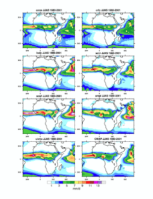
Fig1: Mean seasonal rainfall (JJAS 1980-2001) as simulated by the different coupled models used in DEMETER forecasts, compared to CMAP observations.
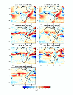
Fig2: Mean seasonal rainfall (JJAS 1980-2001) anomalies as simulated by the different coupled models used in DEMETER forecasts with respect to CMAP observations.
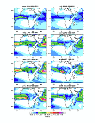
Fig3: Seasonal rainfall (JJAS 1980-2001) standard deviation as simulated by the different coupled models used in DEMETER forecasts, compared to CMAP observations.
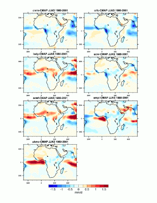
Fig4: Seasonal rainfall (JJAS 1980-2001) standard deviation anomalies as simulated by the different coupled models used in DEMETER forecasts, with respect to CMAP observations.
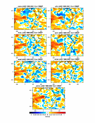
Fig5: Seasonal rainfall (JJAS 1980-2001) spatial correlations between the different coupled models used in DEMETER forecasts, and CMAP observations.
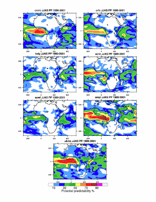 Fig6: Seasonal rainfall (JJAS 1980-2001) potential predictability as simulated by the different coupled models used in DEMETER forecasts.
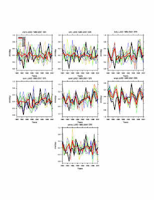
Fig6: Sahelian rainfall index (JJAS 1980-2001, 16W-40E, 10N-20N) as simulated by the different coupled models used in DEMETER forecasts compared to CMAP observations (CMAP black line, Ensemble mean red line).

Fig1: Mean seasonal rainfall (JJAS 1980-2001) as simulated by the different coupled models used in DEMETER forecasts, compared to CMAP observations.

Fig2: Mean seasonal rainfall (JJAS 1980-2001) anomalies as simulated by the different coupled models used in DEMETER forecasts with respect to CMAP observations.

Fig3: Seasonal rainfall (JJAS 1980-2001) standard deviation as simulated by the different coupled models used in DEMETER forecasts, compared to CMAP observations.

Fig4: Seasonal rainfall (JJAS 1980-2001) standard deviation anomalies as simulated by the different coupled models used in DEMETER forecasts, with respect to CMAP observations.

Fig5: Seasonal rainfall (JJAS 1980-2001) spatial correlations between the different coupled models used in DEMETER forecasts, and CMAP observations.
 Fig6: Seasonal rainfall (JJAS 1980-2001) potential predictability as simulated by the different coupled models used in DEMETER forecasts.
Fig6: Sahelian rainfall index (JJAS 1980-2001, 16W-40E, 10N-20N) as simulated by the different coupled models used in DEMETER forecasts compared to CMAP observations (CMAP black line, Ensemble mean red line).
07 February 2008
Easily convert grib files to ncdf
NCL has been successfully installed on the server of the geography Dpt
This soft is able to read both grib and ncdf files
Included a usefull tool to convert grib files to ncdf.
Assuming a file called test.grb
Just try on a linux terminal:
ncl_convert2nc test.grb
It will create a file called test.nc
You can then see the file header by typing:
ncdump -h test.nc
More details:
http://www.ncl.ucar.edu/Applications/griball.shtml/
Tools to modify ncdf files
Nco software:
http://nco.sourceforge.net//
Nco is a usefull tool to modify and to do operations onto netCDF files, using linux/unix command lines. It has been installed on the geography server at the university of Liverpool
Here is just a copy of the nco web site including examples:
http://nco.sourceforge.net//
Nco is a usefull tool to modify and to do operations onto netCDF files, using linux/unix command lines. It has been installed on the geography server at the university of Liverpool
Here is just a copy of the nco web site including examples:
What is NCO?
The netCDF Operators, or NCO, are a suite of programs known as operators. Each operator is a standalone, command line program which is executed at the UNIX shell-level like, e.g., ls or mkdir. The operators take netCDF files as input, then perform a set of operations (e.g., deriving new data, averaging, hyperslabbing, or metadata manipulation) and produce a netCDF file as output. The operators are primarily designed to aid manipulation and analysis of gridded scientific data. The single command style of NCO allows users to manipulate and analyze files interactively and with simple scripts, avoiding the overhead (and some of the power) of a higher level programming environment. The NCO User's Guide illustrates their use with examples from the field of climate modeling and analysis. Note that the “averagers” are misnamed because they perform many non-linear operations as well, e.g., total, minimum, maximum, RMS:
- ncap and ncap2 netCDF Arithmetic Processors (examples)
- ncatted netCDF Attribute Editor (examples)
- ncbo netCDF Binary Operator (includes ncadd, ncsubtract, ncmultiply, ncdivide) (examples)
- ncea netCDF Ensemble Averager (examples)
- ncecat netCDF Ensemble Concatenator (examples)
- ncflint netCDF File Interpolator (examples)
- ncks netCDF Kitchen Sink (examples)
- ncpdq netCDF Permute Dimensions Quickly, Pack Data Quietly (examples)
- ncra netCDF Record Averager (examples)
- ncrcat netCDF Record Concatenator (examples)
- ncrename netCDF Renamer (examples)
- ncwa netCDF Weighted Averager (examples)
The operators are as general as netCDF itself: there are no restrictions on the contents of the netCDF file(s) used as input. NCO's internal routines are completely dynamic and impose no limit on the number or sizes of dimensions, variables, and files. NCO is designed to be used both interactively and with large batch jobs. The default operator behavior is often sufficient for everyday needs, and there are numerous command line (i.e., run-time) options, for special cases. NCO works well on all modern operating systems, including: Apple OS X, *BSD, Cray UNICOS, DEC Tru64, IBM AIX, HPUX, Linux, Microsoft Windows, NEC Super UX, SGI IRIX, and Sun Solaris.
06 February 2008
Animations.....
Here are few personal examples of the IDV software
get the quicktime soft to see the videos:
http//www.apple.com/quicktime/download/
1) Seasonal cycle of the West african monsoon:
Mean seasonal cycle (1950-1999) of mean sea level pressure (shading at the surface) mean 925hPa winds (vectors in white). Tropical easterly jet (U wind at 200hPa, gray contours) African Easterly jet (U wind at 600 hPa, white contours), the vertical section is the temperature.....
You can note the establisment of the monsoon flow during boreal summer, the northward migration of the thermal low following the sun run (see the vertical profile), and the northward migration of the jets, and their westward extension.....
2) Seasonal cycle of the Inter tropical convergence zone (ITCZ), overlayed onto the orography
You can note the influence of the mountains upon rainfall (Cameroon mounts, Fouta djalon, Ethiopian highs). The impact of the Himalaya during the establishment of the Indian monsoon can be noted too......
Usefull tools for climate analysis and teaching
Here are listed few usefull softs concerning climate science
edGCM : simple Global Climate model (an older version of the NASA model) for education and training, it allows to setup climate simulation (scenario, paleoclimate sim....), to visualize the outputs (Eva interface) and to write papers
Really usefull for students......
Can be installed under windows.....
http://edgcm.columbia.edu/
IDV: 3D real time visualization soft. Really usefull to impress people during the conferences....
Can acces real time forcecast of the GISS model via the web (a catalog can be accessed to by URL)
Read both grib and netcdf files......
http://www.unidata.ucar.edu/software/idv/
Share your pc for climate simulations.....
http://www.climateprediction.net/
NCAR portal, allowing to analyze datas, perform statistic analyses and lots of things.....
really easy to use (just push buttons....)
http://www.cdc.noaa.gov/cgi-bin/PublicData/getpage.pl
NCL: Ncar language, son of ncargraphix
really usefull to perform analysis and to do nice plots for papers:
http://www.ncl.ucar.edu/
edGCM : simple Global Climate model (an older version of the NASA model) for education and training, it allows to setup climate simulation (scenario, paleoclimate sim....), to visualize the outputs (Eva interface) and to write papers
Really usefull for students......
Can be installed under windows.....
http://edgcm.columbia.edu/
IDV: 3D real time visualization soft. Really usefull to impress people during the conferences....
Can acces real time forcecast of the GISS model via the web (a catalog can be accessed to by URL)
Read both grib and netcdf files......
http://www.unidata.ucar.edu
Share your pc for climate simulations.....
http://www.climateprediction
NCAR portal, allowing to analyze datas, perform statistic analyses and lots of things.....
really easy to use (just push buttons....)
http://www.cdc.noaa.gov/cgi
NCL: Ncar language, son of ncargraphix
really usefull to perform analysis and to do nice plots for papers:
http://www.ncl.ucar.edu/
Subscribe to:
Posts (Atom)